FAQ
HYPACKに関する質問
4.ハードウェアのセットアップ(Hardware)
ID.Q4-18S
Q. キネマティックGPS用ドライバ(Updated Kinematic.dll)[英語]
A.
The kinematic.dll has recently been updated with added flexibility to accommodate more GPS messages. The user now has a choice of warning lights in the Survey program based on the GPS quality indicator within the data string. This modification was a necessity, due to the update of the NMEA 0183 standards (Version 3.0), and also for the GPS manufacturers that don't comply with the NMEA standards (Yep, we know who you are!).
The GPS quality indicator warns the user that they have dropped out of a mode, such as differential or kinematic, and is used in Hypack®'s NMEA-0183 (nmea.dll) and Kinematic GPS (Real-Time-Tides) (kinematic.dll) device drivers. This would result in a loss of position accuracy and, in the case of the kinematic driver, would also result in a loss of horizontal accuracy. Because the Kinematic driver is used to record water levels in real time, the recorded tide value in non-kinematic mode would end up being...well...junk.
These are the NMEA GPS quality indicators in a GGA string:
0 = Fix not available or invalid
1 = GPS SPS Mode, fix valid
2 = Differential GPS, SPS Mode, fix valid
3 = GPS PPS Mode, fix valid
4 = Real Time Kinematic. System used in RTK mode with fixed integers
5 = Float RTK. Satellite system used in RTK mode, floating integers
6 = Estimated (dead reckoning) Mode
7 = Manual Input Mode
8 = Simulator Mode
The previous kinematic driver had a quality indicator hard coded within the driver. The value of 3 was considered kinematic, so if the GPS output any other value other than 3, you would get a warning light in the Survey program. This worked for most GPSs, but not all.
The Setup dialog in the kinematic.dll now allows the user to change the quality indicator (see figure below).
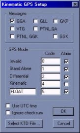
The user simply checks the alarm they would like to see in the Survey program. There is also a user-defined field, so you can choose the number code and the alarm message (see below).
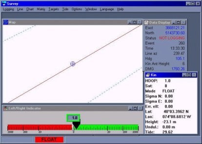
The GPS Mode, number of satellites, HDOP, and antenna height are also output to the shared memory area while running in Survey.