FAQ
HYPACKに関する質問
3.測地系(Geodesy)
ID.Q3-5
Q. データ変換プログラムの7つのパラメータ(New 7-Parameter Datum Transformations Program)[英語]
A.
Mircea Neacsu has recently completed a new program that allows users to calculate the 3-parameter or 7-parameter datum transformation parameters from a list of geographic coordinates.
For our example, I want to compute both the 3-parameter and 7-parameter transformations for the island of Macau. Macau operates on an Azimuthal Equidistant projection that is based off the International ellipsoid.
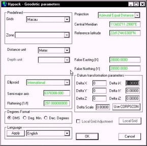
To get started, I have made a HYPACK MAX project and called it Macau. I have set the geodetic parameters to the local Macau grid, as it is a pre-defined grid available from the menu. What is missing is the Datum Transformation information.
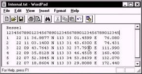
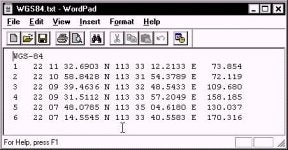
I have a list of six points on the island. One list is in WGS-84 and the other list is in International. I have typed the two lists into a TXT file (using Notepad), using a fixed format so that all the items are aligned. This will be important later on. I also have a typo in the Internal.txt file. I entered "Bessel" as the first word. This doesn't matter, as the program is going to read the GEODETIC PARAMETERS from the project and figure out that it is really an International ellipsoid.
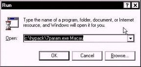
I then start the program from the Run menu. Since this is so new, there is not yet a MAX menu item for the program. The program is in the \HYPACK directory. You need to add a space after the name of the program and then enter the name of the project. The program will read the geodesy from the named project to figure out what ellipsoid you are working on.
When the program first starts, it puts up this humorous screen, providing a few details and insights. After you get tired of reading it, you can click the "Very funny…" box and you won't have to read it again.
Click the "Next" button and you are taken to the next window.
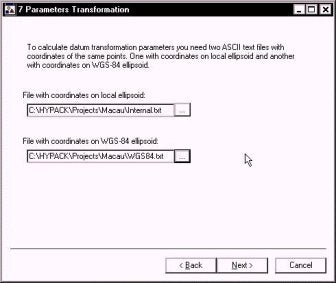
In this window, I give it the name of the two TXT files that have the geographic coordinates (Lat, Long and Ellipsoid Height) for each of the data points. These files can be anywhere on your computer or network.
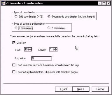
In the next window, I start by telling the program that my TXT files contain "Geographic coordinates".
I can then select to determine the best 3 parameter or 7 parameter transformation that fits the data points.
The "Use Key" option allows you to ignore any line in your text file that does not contain the "Key" letter. In our case, we are looking for the letter "N" in the 19th column of each line to denote a record we want to use.
The "Load files now to check how many records match the key" will pre-read each of the files and show you how many points have met the "key" criteria. You want the same number of points in each file.
The "I defined my fields before. Skip over field definition pages" will proceed directly to the computation. If you haven't defined your fields (and I haven't defined them yet), don't check this. Once you have defined where the information in your TXT files is placed, you won't have to go through this every time.
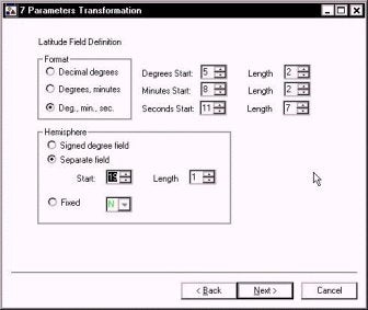
In the figure to the right, I have defined where to look in each record for the latitude information.
I am reading Degrees-Minutes-Seconds from each record. The degrees start in column five and are two characters long. The minutes start in column 8 and are two
characters long. The seconds start in column 11 and are 7 characters long.
My hemisphere identifier (N) is in column 19.
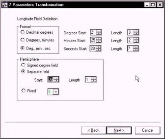
In the next window, I do the same for my longitude information.
The format is once again Degrees-Minutes-Seconds.
My degree information starts in column 21 and is 3 characters long. My minute information starts in column 25 and is two characters long. My seconds value starts in column 28 and is 7 characters long.
The hemisphere identifier (E) is in column 36.
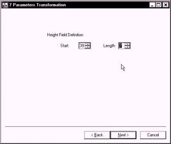
The position of the Height above ellipsoid for the record is entered in the next window.
In our example, the height value starts in column 39 and is 7 characters long.
Please note that for foot-based grids, you still need to enter the height as a metric value. We're working on this, but it isn't ready as of this time.
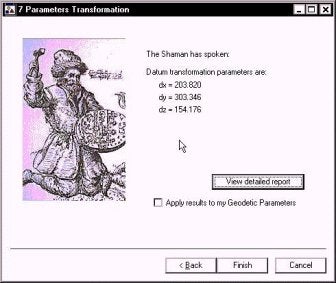
The program then reports the 3-parameter information in the window shown to the right.
If you click the "Apply results to my Geodetic Parameters", then the information is added automatically to your GEODETIC PARAMETERS of the specified MAX project.
If you click the View Detailed Report button, a text report that summarizes the transformation is provided. This also provides residual errors for each of the transformed points.
Datum transformation report

Using geodetic parameters from C:\HYPACK\projects\Macau\Macau.ini
Local ellipsoid is International
Semi major axis: 6378388.000
Flattening:      297.0000000l

Loading C:\HYPACK\Projects\Macau\Internal.txt
6 records meet key criteria
6 records loaded

Geocentric coordinates
----------------------
  -2360868.965    5416590.714    2394336.311
  -2358981.316    5417840.268    2393371.637
  -2360785.882    5418097.292    2391124.776
  -2362644.063    5417436.829    2390916.516
  -2364883.766    5417739.465    2387959.063
  -2362845.969    5419093.046    2387019.007

Loading C:\HYPACK\Projects\Macau\WGS84.txt
6 records meet key criteria
6 records loaded

Geocentric coordinates
----------------------
  -2361072.795    5416287.420    2394182.211
  -2359185.118    5417536.995    2393217.519
  -2360989.678    5417793.911    2390970.578
  -2362847.875    5417133.429    2390762.329
  -2365087.616    5417436.088    2387804.847
  -2363049.798    5418789.694    2386864.767

Performing 3 parameters adjustment...

Datum transformation parameters from WGS-84 to local ellipsoid
--------------------------------------------------------------
dx = 203.820  dy = 303.346  dz = 154.176

Residuals
---------
 0.009
 0.009
 0.002
 0.003
 0.003
 0.004
Cumulative residual: 0.031
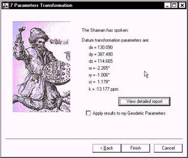
The same routine is followed for computing a 7-parameter transformation. The resulting parameters are reported and can be transferred to the GEODETIC PARAMETERS information as described above.